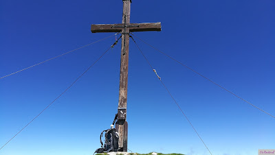
The prolonged Ascension Day weekend of 2018 held lots of new stuff and surprises for me.
But before I will start telling you about those, I would like to explain the title "Himmelfahrtskommando" because it's a wordplay with German words. The holiday "Himmelfahrt" (Ascension Day in English) is usually a prolonged holiday in Germany. The word in the title "Himmelfahrtskommando" means "kamikaze/suicide mission". Both contain the part "Himmelfahrt" and because our tour took place during the Ascenion Day holidays (Himmelfahrts-Feiertag) and was like a kamikaze mission in some parts, I picked that word as a wordplay for that trip.
DF and me drove after a very thorough check of the weather forecast to Griesen (near Garmisch-Partenkirchen) on Thursday evening. Our goal was to make a ridge walk on the following day. The whole undertaking was something completely new for me as you will see in the following points:
- first mountain tour alone with DF 😊
- first time sleeping in a car
- first trackless ridge walk
- Little Stoffel's first tour ever
- first descent in the darkness (not planned)
But I rather start with the beginning. First of all things, Little Stoffel was ready to leave before me and impatiently waited on my trekking backpack.
 |
| Ready to go!!! |
DF and me used the Thursday for packing and the drive. We found an asphalted and plain parking space close to the beginning of our hiking route in Griesen and we declared it to our department point. Since it was only 07:30 pm, we still had some daylight left to take a closer look to our surroundings.
I knew the way until the junction to the Schellschlicht because I had already done that tour in August 2017. DF and I wanted to start via the Friederspitz but unfortunately there was not the tiniest, official sign for that in this area. First, we had planned to ascend via the so called Nudelgraben ("noodle ditch" - who names locations like that?!) but we changed our plans because of the difficult terrain. Our priority for the ascend was to get ahead as fast as possible.
It was the second way on the right hand after the signposted junction towards the Rotmoosalm. It was a bit of surprise and a letdown that there were no real signs into the direction of the Frieder down in the valley - besides that someone had manually added the mountain Frieder on the sign to the Rotmoosalm. It was even more surprising because the Friedergrieß was signposted.
It was time to get to sleep after that short expedition. The alarm was set for 04:45 am. The "bed" was something that I had to get used to first:
 |
| The trunk of my Fabia |
The next morning we started already at 06:00 am, because our tour promised to be lengthy. Our route led to the Friederspitz, over the ridge to the Kreuzspitzl, further on to the Schellschlicht and back to Griesen in the end. It had a distance of about 20 km and 2.000 height meters. The clouds hung so deep, that we had no view at all at the beginning.
Our route above the Nudelgraben towards the Friedergries had already a catch after only a few hundred meters. We were aware of walking through a natural reserve, but to stand in front of a high fence all of a sudden, which was surrounding an area for wildlife feeding, was completely unexpected. It wouldn't have been so bizarre, but the official forest trail was blocked by the fence and if the fence had been right on the other side, the trail would have been passable. So, we had to look for a smaller trail to walk parallely to the fence. The footprints were proof, that we were not the first ones doing it.
We reached the Friedergries, where we had to cross a little stream at 06:40 am.
 |
| A Youtuber in the Friedergries. 😀 |
 |
| On the road again |
 |
| Misty mountains |
 |
| Wetterstein mountains |
 |
| Team Stoffel on its way to the Friederspitz |
 |
| Little Stoffel at the Friederspitz |
We reached the Friederspitz (2.049 m) at 11:00 am and renounced the Frieder, because of our tight schedule. There was a terrible draft up there, so we only had a very short break to eat, before we marched on towards the ridge.
 |
| View to the Frieder |
 |
| View to the ridge |
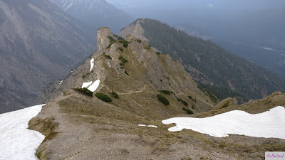
The ridge switched between easy walking parts, fields of mountain pines or climbing in the further course. The stone was extremely brittle, so we often held the whole thing in our hands instead of being able to hold on to it. Additionally, there was a lot of slippery grit, which made it impossible to stand safely from time to time.
 |
| Mind your step |
 |
| Ridge walk |
It started raining again and again shortly after that and the thunder rolled unsettling towards us from the Wetterstein mountains. We hurried up to reach the Kreuzspitzl as fast as possible and to get down from there.
DF and me reached the highest point of our ridge walk at 17:10 pm. The thunderstorm had calmed down and we continued our descent towards the Schellschlicht.
 |
| Ridge to the Schellschlicht |
 |
| Three Stoffel on the Schellschlicht |
I had a little highlight, because I found my old summit register entry from the 24th of August 2017. A new entry and a short break later, we began with the descent. We still had 1.200 m height meters ahead of us.
 |
| Descent from the Schellschlicht |
We still were about 1.200 m high at 21:10 pm and it was time to take out our flash lights to make out the trail in the thick Schellwald (Schell-forest). It was a huge advantage, that I still remembered the way from my tour, which I had made one year earlier.
We returned to our car at 22:30 pm, 16 1/2 hours after our start in the morning. I think it's understandable, that we "robbed" a fast food restaurant after that...😁
Conclusion for the tour: Extremely demanding!!!
The tour was worth it, but DF and I agree, that we won't make a ridge walk in the Ammergauer Alps in the near future. Some research afterwards revealed to us, that most ridges there are known for the very "safe" and not brittle stone - and there are really things that are more reassuring.
The tour needs surefootedness like a chamois and lots of courage. It was a very tough one as a starter for 2018.
The view was incredible and I can suggest a visit to the Friederspitz and the Frieder, if you are looking for a nice hiking tour to enjoy.
You can find DF's Youtube video here: Himmelfahrtskommando - Gratwanderung über Friederspitz, Kreuzspitzl und Schellschlicht. 😉
See ya 'til the next mischieve!
Your Katharina

Ich finde es toll, Gruss Gwenni
AntwortenLöschen